Since our founding in 2010, MCVL Realty has identified itself as “specializing exclusively in the McClellanville / Awendaw area”. You would think with such a claim that if anyone were to know the Awendaw boundary, it would be us. Unfortunately, the problem is not so much “where” the boundary is, but rather “which” one you want to use!
For the purpose of serving our clients, MCVL Realty doesn’t need to draw a hard line. We gladly include our neighbors to the west, Huger and Jamestown, within our service area as they fall right into the rural niche that we love to serve. It’s a different set of knowledge and marketing skills that go into selling town homes, condos, and cookie-cutter subdivisions if we go further south into Mount Pleasant. We have relationships with a lot of stellar agents that work there that we are always happy to refer your business to. The general rule of thumb for us is if the majority of the residents are wildlife, not humans, then it’s our neck of the woods!
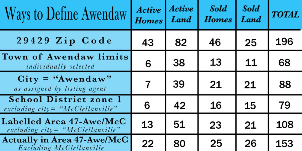
The real trouble comes when conducting real estate searches and pulling statistical data about sales and listings in the area. Awendaw can be defined by zip code, town limits, MLS zone, school district and more. Depending on which one of these methods you choose the results will vary greatly. As an example, there are currently 43 active listings in Awendaw’s zip code while there are only 6 in the town limits.
The US Postal Service introduced zip codes in 1963. The region known as Awendaw, taken from the Seewee Indian tribe, was assigned 29429. One can only assume that the size and shape of the zip codes correlated to mail delivery. They kept the western border fairly close to the Charleston/Berkeley county line, but it still meanders a bit. They extended just a bit northward beyond Awendaw Creek which would have seemed the logical boundary to me. The southern boundary was established in what was largely a no man’s land at the time, miles from the small town of Mount Pleasant and its ~5000 residents. The zip code created a formal boundary of properties that received their mail in “Awendaw, SC 29429”. Since that time zip codes have become an extremely common method of sorting information such as census data, crime statistics, and election poll results but it is reasonable to define an area on a decision made by the postal service more than 50 years ago?
In 1992, residents of Awendaw incorporated into a town and they have been growing those boundaries by annexing more land ever since. The process of annexation requires an adjacent property outside of the jurisdiction to both request to be included and the municipality to vote and agree to accept that property. The Town of Awendaw has chosen not to accept some properties and there are legal disputes challenging the procedural methods used to annex others. All of this means that only a fraction of the zip code is contained within the town limits and most remains as unincorporated Charleston County.
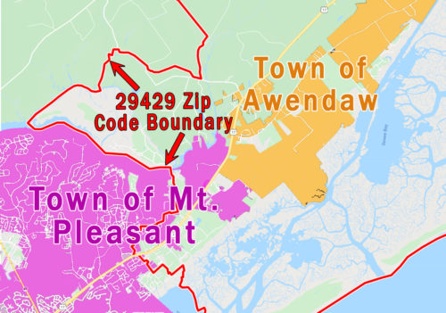
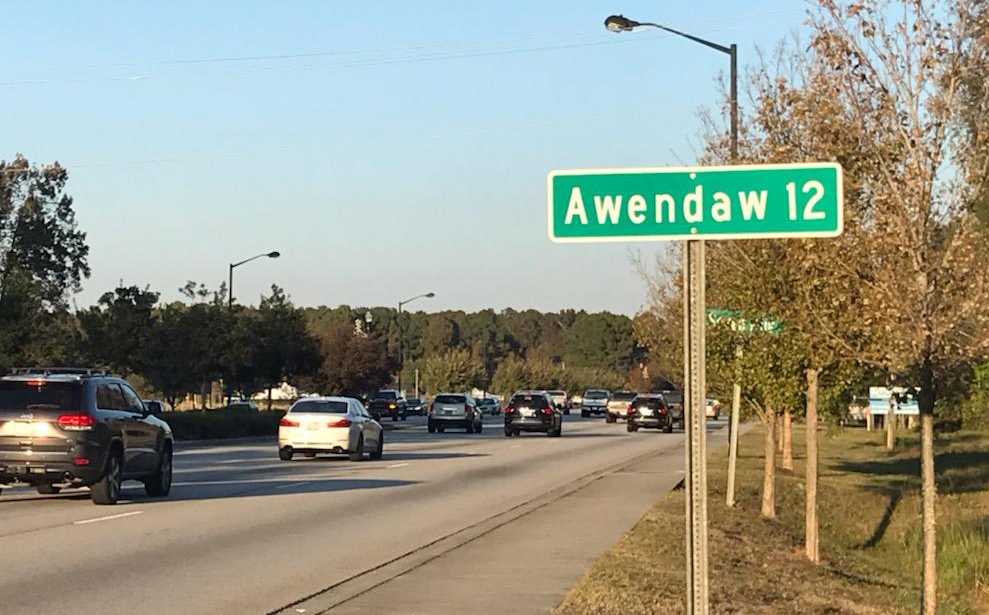
Since mail delivery has no correlation to municipalities, the Town of Mount Pleasant was able to annex properties well into Awendaw’s zip code. In 2016 Mount Pleasant annexed its northernmost territory, the Bulls Bay Golf Club extending from Hwy 17 to the Intracoastal Waterway. You may not recognize this landmark by name even if you travel these roads because the only indication they have on Hwy 17 is a sign consisting of bull horns at their entrance. The Town of Awendaw has annexed southward to this point as well, creating a fairly firm boundary. It is just beyond this point, at the next natural clearing, that a “Town of Awendaw” sign indicates your entry.
The strange disconnect between zip code and municipal boundaries causes a lot of confusion to residents unsure of what ordinances apply to them and which services they are entitled. Charleston County has not helped matters by providing little oversight in the official address that is recorded on tax records. There are residents throughout Awendaw that use “Mt Pleasant, SC 29429” as their mailing address. I don’t think the post office cares if you put Kalamazoo, SC as they go by the zip code. The mere fact that your property records show a Mount Pleasant mailing address has no bearing on anything and I could probably submit my address in McClellanville as Mount Pleasant, SC 29458 with no problem other than occasional delays in mail delivery. In contrast, Bee’s Crossing, D.R. Horton’s latest development on the northern edge of Mount Pleasant has a 29429 zip code. You probably won’t see any mention of Awendaw as they are looking for buyers who desire to be identified as residents of “Mt.P”, nonetheless their mail is routed through the Awendaw post office.
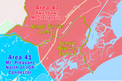
For education purposes, the Charleston County School District lumped McClellanville and Awendaw together into attendance zone 1. I can’t say what factors determined the boundary between this area and zone 2 which serves Mount Pleasant, but there seems to be no rhyme or reason behind its placement. It includes a few houses on 15 Mile Landing Road behind Seewee Restaurant and then bisects nearly half of Sewee Road with residents on either side of the road zoned for different school districts. These lines became less important with the closing of McClellanville’s Lincoln High School which made Wando the high school serving all of zone 1 and 2. Elementary and Middle School children in zone 1 go to St. James-Santee in McClellanville, but have also been allowed to transfer to Mt. Pleasant schools. Cape Romain Environmental Education Charter School (CREECS for short) in McClellanville is not part of Charleston County School District and accepts children from anywhere in the state. Negotiations are on-going for land to build a new high school in Awendaw which would result in redrawing of attendance zones and it is likely that children in northern Mount Pleasant will be driving past Wando to attend this new school. The land may also include room for a new future elementary and/or middle school as well.
School districts may play an important part in the real estate process for many, but I also took the time to explain this because it just so happens that our local MLS chose to copy the school attendance zone when they created area “47-Awendaw/McClellanville”. The average person doesn’t know or care about which MLS area they live, so in that regard it has no bearing on our lives. They are, however, a vital method for agents to sort listing quickly. It just so happens that much of the real estate data is provided to us only by MLS area, so from that standpoint, this becomes yet another way to define Awendaw.
It’s important to understand that real estate agents are responsible for entering the area, city, and subdivision that a new listing is placed in. We are given the boundaries and the system all but does it automatically and yet there is still a lot of inaccuracies in what is entered. Some errors come from all of the previously mentioned confusions such as the city name shown on the county records being incorrect, but as around one third of the listings are entered incorrectly I believe that most are done purposefully. Mt. Pleasant is a larger area and has more people searching within it, so some agents think that entering an Awendaw listing in the city of “Mt. Pleasant” or area of “41-Mt Pleasant North of IOP” is going to get their listing bonus traffic. The frequencies of these errors increase with the dollar value of the property leading me to believe that people feel the Mt. Pleasant name also carries more prestige than Awendaw. In reality, mislabeling properties only makes it more difficult for agents that are legitimately looking for Awendaw properties to find them.
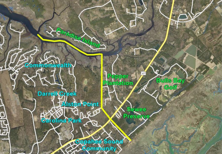
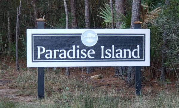
Due to the importance of these MLS areas for statistical data, I made a formal request to the board of our MLS in 2016 to adjust the boundaries. Despite ALL of the previously mentioned boundaries, my suggestion was to redraw the lines based on yet another factor. I proposed that there was a significant observable distinction between rural and suburban neighborhoods that fell between zip code boundaries and the town limits. The neighborhoods of Paradise Island, Pepper Plantation, Sewee Preserve, and Bulls Bay Golf Course had features that are more commonly pursued by buyers looking for rural property, while Carolina Park and Park West were certainly more suburban. Copahee Sound is a strange mix of both, but with Mount Pleasant zoning it will certainly become more and more suburban. The MLS board reviewed my recommendations and agreed to implement them a few months later. So here I am, complaining about the vast number of ways to define Awendaw and rather than fix the problem, I added one more to the stack. The truth is that these really aren’t problems and they can’t be fixed. They are what they are and create confusion and obstacles, but the solution is to work with agents that are knowledgeable about subjects like this which effect the real estate process.
Three years after the shift in MLS boundaries real estate agents aren’t doing much better properly assigning listings to the correct area. The MLS provided us with a better mapping tool to show agents where the MLS areas were located, but it still escapes some of us. Currently 40 out of 98 listings that belong in area 47 are incorrectly labelled as area 41 and won’t be counted located in these searches or count in any statistical data greatly skewing the data.
The data below shows the vast difference between the variously defined areas known as “Awendaw” and highlights a need for a consistent standard to avoid grossly skewed data and conclusions. As an agent that specializes in this market, it is my job to be constantly researching the market to stay on top of every listing and sale. Labeling irregularities make this job harder, but can also harm appraisers abilities to find the comparable sales that they rely on so heavily. More than anything these mislabeled properties hurt the sellers of these properties. The MLS is full of expired listings located in Awendaw but labelled as Mount Pleasant that would have surely garnered much more attention if labelled correctly. It’s not uncommon for us to get calls from owners wanting to relist their property and we aren’t even able to find it in the MLS. Of course it didn’t sell if the #1 real estate office isn’t even aware of it how are we supposed to pass it along to all of our buyer clients?